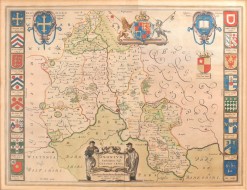
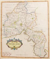
Oxonium
Comitatus, Vulgo Oxfordshire

1645.
385mm x 505mm. A fine, engraved, hand-coloured map of Oxfordshire by one of the most famous cartographers of the period. Details include hills and parks as well as towns and villages. Royal coat of arms at head, embellished in gilt. Oxford college crests to borders and decorative cartouche at the foot of the map. Central crease where folded, some offsetting to upper corner, but a crisp, bright example of this important map.
The Blaeu family were perhaps the pre-eminent seventeenth century publishers of maps, globes and atlases. Joan Blaeu's English and Welsh county maps were printed in the fourth volume of Theatrum Orbis Terrarum in 1645.
LITERATURE: BLAEU, Joan Theatrum Orbis Terrarum (1645)
Stock ID: 37944
Sold
We have sold this item, but similar items
may become available in the future