From its Spring in Gloucestershire, to its Influx into the Sea; with a Table of all the Locks, Wears, and Bridges thereupon: Shewing the Tolls payable at each and their distance by Water from one another.


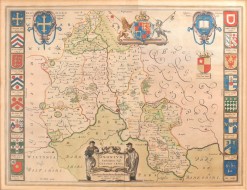
Bowles's New Map of the River Thames From its Spring in Gloucestershire, to its Influx into the Sea; with a Table of all the Locks, Wears, and Bridges thereupon: Shewing the Tolls payable at each and their distance by Water from one another.
Bowles & Carver, 1816.
Engraved map with full wash colour, in twelve part mounted on linen. Housed in original card case with title label to upper cover. Very good indeed with some wear to the case. Ownership name to the upper right corner.
A fine early map of the Thames, which contains details of tolls payable at various bridges and a small piece on the origins of Thames and the fish which can be found in it.
Stock ID: 34288
Sold
We have sold this item, but similar items
may become available in the future