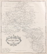
FIRST EDITION TOMBLESON MAP WITH CONTEMPORARY HAND COLOURING
Tombleson's Panoramic Map of the Thames and Medway
J.Reynolds, 1834.
First edition. 11''x 4'3''. India paper with steel engraving of the Thames from its source in Gloucestershire to the sea with detail of the towns and countryside through which it passes. Finely hand coloured, whilst still retaining the clarity of line in the steel engraving. A fine copy, subtly hand coloured with excellent detailing. A beautiful example of one of the finest maps of the Thames.
This map was issued as an accompaniment to the book, Tombleson's Thames, and is generally a black and white steel engraving. However, "copies of this edition are met with, where the plates are coloured....[and] the map is similarly altered." (Cohen - The Thames 1580-1980 A General Bibliography)
Due to its popularity the map was reprinted and lithographically coloured for many years, but the clarity of the engraving of these later editions is noticeably inferior. Examples of the first edition with contemporary colouring are rare.
Cohen p.184-185
Stock ID: 31667
Sold
We have sold this item, but similar items
may become available in the future