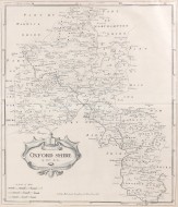
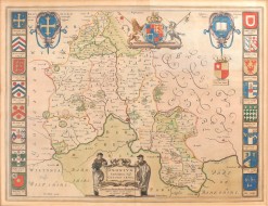
Map of Oxford Shire

MORDEN, Robert

MORDEN, Robert Map of Oxford Shire

1722.

418mm x 358mm. Original copper engraved map. A fine copy.

Produced by Morden for the 1722 edition of Camden's Britannia. Morden was employed to replace the outdated maps by Saxton, engraved by Kip and Hole. He based his maps on manuscript sources plus the surveys of Ogilby and Morgan, seller, Palmer and the coastal charts of Cpt. Greenville Collins. These maps were the first to show the roads based on Ogilby's earlier work of 1675, and included 3 scales to cover the various scales used in different parts of the country.
Bishop Gibson described the maps from this series as "much the fairest and most correct of any that have yet appeared"

Stock ID: 30380

Sold

We have sold this item, but similar items
may become available in the future

Register interest Add to favourites

Browse related books

Oxfordshire

MORDEN, Robert

£250.00

Oxfordshire

MORDEN, Robert

£375.00

Oxfordshire

MORDEN, Robert

£375.00

Blenheim Woodstock, Etc

TAUNT, Henry W.

£300.00

Iffley Manor, Church, and Village

TAUNT, Henry W.

£125.00

Canterbury

KEESEY, Walter M.

£20.00

The History of Hertfordshire

SALMON, Nathaniel

£350.00

The Waveless Plain

STARKIE, Walter

£15.00

Cote d'emeraude

MUSSON, S.C.

£80.00

The River Thames From Oxford to the Sea

ADAMS, W. H Davenport

£175.00

The Manor and Parish Records of Medmenham Buckinghamshire

PLAISTED, Arthur H.

£125.00

Life on the Upper Thames

ROBERTSON, H.R.

£175.00

The Thames Guide Book

HARRISON, A.H.

£75.00

Views on the Thames

COOKE, W.B. & George

£1,200.00

The Royal River

et al / SENIOR, William

£300.00

The Thames and Its Tributaries

MACKAY, Charles

£125.00

Salter's Guide to the Thames 1935

SALTER, J.A. / SALTER, J.H.

£75.00

Salter's Guide to the Thames 1936

SALTER, J.H. / SALTER, J.A.

£60.00

Provincia Oxoniensis

Jansson, Jan

£1,500.00

Tombleson's Thames

TOMBLESON, William

£600.00